Resource information
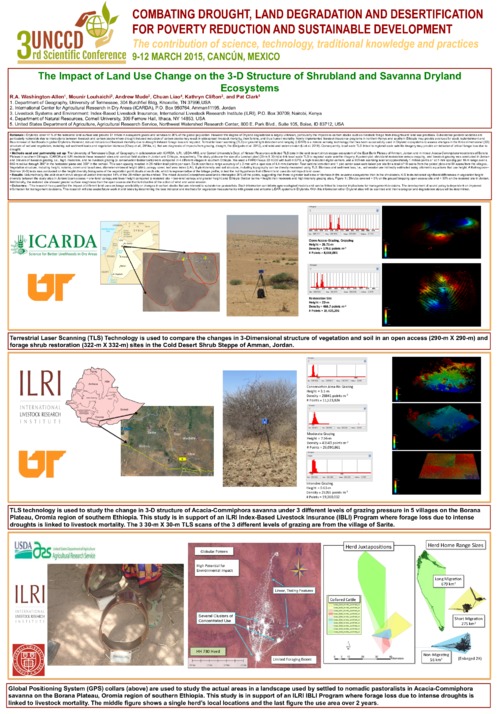
The University of Tennessee’s Dept. of Geography in collaboration with ICARDA, ILRI, USDA-ARS, and Cornell University’s Dept. of Natural Resources collected TLS data in the cold desert shrub-steppe ecosystem of the East Bank Plateau of Amman, Jordan and in mixed Acacia-Commiphora woodlands of Borana Plateau in southern Ethiopia. ICARDA and ILRI maintain these research sites and conduct field studies in Jordan and Ethiopia, respectively. The study plots are the size of a Landsat pixel (30-m X 30-m) to link local scale TLS to regional scale satellite imagery. A paired-plot: shrubland restoration versus cropping, and livestock grazing was conducted in Jordan and 3-levels of livestock grazing, i.e., high, moderate, and no livestock grazing (a conservation fodder bank) were compared in 4 different villages in southern Ethiopia. We used a FARO Focus 3D X330 with built in GPS, a high resolution digital camera, and a 905-nm scanning laser at approximately 1 million points s-1 at 7-mm spacing per 10-m range over a 650-m radius through 360° in the horizontal plane and 300° in the vertical. This scan spacing resulted in 28 million total points per scan. Each scan has a range accuracy of ± 2-mm with a spot size of 4.5-mm diameter. Four cardinal direction and 1 plot center scan were taken per site for a total of 10 scans from the paired plots and 61 scans from the villages.. Vegetation structure, including height, volume, crown and basal area, diameter-at-breast height (dbh) ,canopy cover, leaf area index (LAI), & plant density and soil structure, including topography can be directly measured using TLS. Biomass and sediment loss, i.e., soil erosion are indirectly estimated using allometric equations that use height. A Kolmogorov– Smirnov (K-S) tests was conducted on the height diversity histograms of the vegetation point clouds at each site, which is representative of the foliage profile, to test the null hypothesis that different land uses do not impact land cover.
This research has quantified the impact of different land uses on forage availability or changes in carbon stocks that are relevant to subsistence pastoralists. Such information can inform agro-ecological models and can be linked to broader implications for management decisions. The development of sound policy is dependent on improved information for management decisions. This research will also assist future work in arid lands by determining the best indicator and methods for vegetation measurements with ground and airborne LiDAR systems in Drylands. With this information other Dryland sites will be scanned and their ecological and degradation status will be determined.