Location
As a service provider in the field of international cooperation for sustainable development and international education work, we are dedicated to shaping a future worth living around the world. We have over 50 years of experience in a wide variety of areas, including economic development and employment promotion, energy and the environment, and peace and security. The diverse expertise of our federal enterprise is in demand around the globe – from the German Government, European Union institutions, the United Nations, the private sector, and governments of other countries. We work with businesses, civil society actors and research institutions, fostering successful interaction between development policy and other policy fields and areas of activity. Our main commissioning party is the German Federal Ministry for Economic Cooperation and Development (BMZ). The commissioning parties and cooperation partners all place their trust in GIZ, and we work with them to generate ideas for political, social and economic change, to develop these into concrete plans and to implement them. Since we are a public-benefit federal enterprise, German and European values are central to our work. Together with our partners in national governments worldwide and cooperation partners from the worlds of business, research and civil society, we work flexibly to deliver effective solutions that offer people better prospects and sustainably improve their living conditions.
Members:
Resources
Displaying 326 - 330 of 334Land Titles for Indigenous Communities in Peru
General
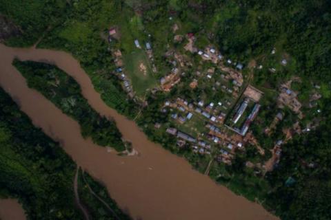
Context The Peruvian Amazon region is home to more than 50 indigenous peoples living in almost 2,270 communities. Around 30% of these communities – 680 – still have no collective land titles (government data 3/2020). This legal uncertainty causes disputes over land, exploitation of natural resources and growing pressure on indigenous territories as a result of infrastructure and industry projects and the influx of settlers from other parts of Peru. Over the decade until 2015, virtually no collective land titles were granted to indigenous communities. The reasons include a lack of clarity over responsibilities, inadequate capacity and budget limitations. The governing role for land titling was transferred back to the Ministry of Agriculture and Irrigation (MINAGRI) in 2014, but regional government agencies remain in charge of the day to day implementation. Since late 2015, German development cooperation − in coordination with other international actors − has been addressing the need for standardised databases, simpler procedures for granting titles, guidelines on the involvement of indigenous peoples and communities, and dispute resolution strategies, as well as capacity development and adequate budgets. Activities in Peru The project supports the granting of land titles to indigenous communities in the Ucayali and San Martín regions and improvements in processes at national level. In field of activity 1, the project is advising MINAGRI and regional agencies on drawing up and improving procedures for granting land titles. It is also supporting further development of the statutory framework for collective land rights, including procedures for preventing and mediating in land disputes. Activities in field of activity 2 are strengthening the national- and regional-level participation of civil society, especially indigenous organizations, in granting land titles to indigenous communities All project activities focus particularly on the rights and concerns of indigenous women who play an important role in ensuring food security but are often disadvantaged in terms of access to land. Impact at two interconnected levels Guaranteeing the land rights of indigenous peoples requires reliable cadastral information. When the project started, cadastral information was only available in outdated Excel files (national level) and insufficiently organized physical files (regional level). To address this situation, the project applied a multilevel approach and supported its partners in the development and consolidation of two complementary digital cadaster systems. At regional level, since 2016 young indigenous professionals worked as project interns for 6-12 months in the systematization and digitalization of approx. 250 community files in both regions. This initiative also improved the technical skills and employability of these young professionals. At national level, MINAGRI launched two digital cadaster systems in 2018 which had been developed with project support. The Cadastral System for Rural Properties (SICAR) is a modern tool for online rural cadaster data updating which focuses on individual (usually non-indigenous) rural properties. Its main innovations are the interoperability with diverse governmental information systems (e.g. on natural protected areas, production forests, mining and oil concessions) and a public viewer to visualize individual rural properties, indigenous communities, concessions etc. The SICAR consolidates the information registered by the 25 regional governments of Peru and is accessible to public users. The transparency it creates helps to prevent land conflicts with indigenous communities. The second system called SIC-Comunidades (Cadastral System for Communities) for the first time provides information on peasant and native communities of the Andes and the Amazon, respectively. It is an innovative web application (also with a map viewer) which allows to follow and monitor the - often lengthy - legal recognition and collective titling procedures. To protect indigenous rights, it can currently only be accessed by registered users, mainly the regional governments but also the indigenous umbrella organization. The work done by the indigenous interns since 2016 prepared the ground for consultancies to upload cadastral information on all (San Martín) or a large part (Ucayali) of native communities into the SIC-Comunidades, an important contribution to enhance their tenure security.
Responsible Land Policy in Uganda
General
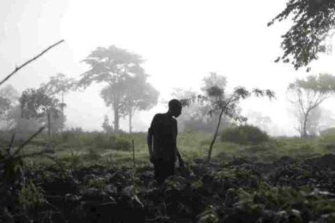
Context With an average of 213 inhabitants per km2, population density in Uganda is very high in comparison with other African countries. The population is growing by more than 3.3% per year. Land in Uganda is increasingly being fragmented due to inheritance rules. As a result, land ownership is being split up and competition between different user groups is on the rise. This situation is exacerbated both by the presence of more than 1.4 million refugees from neighbouring countries (as of March 2020) and by large-scale land investment by national and international investors. Against this backdrop of growing competition for dwindling land resources, fair and secure land rights are increasingly important. Uganda has created a favourable framework for reform of land law through a progressive constitution and land policy. The global project is working with local institutions to advance the granting of use and ownership certificates for smallholders as a basis for economic growth and food security. Activities in Uganda The project works in three fields of action: Activities in field 1 aim at improving the institutional framework and processes for ensuring land rights. This involves a systematic inventory of land which is the basis for applications for land ownership or use certificates. As part of field 2, civil society is strengthened in regard to responsible land policy and in its capacities to provide information to the population and conducting dialogues with the Government and the private sector. The aim is also that civil society cooperates with the project as an implementing partner. The aim of field of action 3 is to raise agricultural investors’ awareness of responsible land policy. The project is providing advisory services to familiarise investors with relevant international standards, such as the Voluntary Guidelines on the Responsible Governance of Tenure (VGGT). An example from the field Less than 10% of all land plots in Uganda are formally registered. Rural populations are particularly likely to lack the documentation to protect their land rights. For this reason, traditional land ownership rights can often be established only with testimony from neighbours, village elders or clan representatives. Attaining land titles or land certificates is a lengthy and costly process and, for most of the rural population, simply not possible. The project Responsible Land Policy in Uganda is working in this area to ensure systematic documentation of the land rights of those living in rural areas. The first stage of the project involves informing the target population about its rights and its scope for protecting its land rights in the long term. One aspect is strengthening women’s rights since land rights are often passed down exclusively to male descendants. The second stage is to establish systematic land inventories at village level, surveying individual land plots digitally and collecting the necessary information concerning owners and users. The resulting land inventory protocols (LIPs) include all necessary information on neighbours, clans and parcels of land. The documented testimonies of neighbours and clans play a decisive role in avoiding future land conflicts. The LIPs are an adapted and pragmatic minimum standard for securing land rights: the systematic approach markedly reduces the work and costs involved. The LIPs also function as security when holders apply for small loans. LIPs therefore not only improve the land rights situation of those involved but also facilitate their access to credit to enable them to invest in their land. This gives entire families a better future.
Applying the VGGT to the responsible development of a large-scale oil palm plantation in Sierra Leone
General
Natural Habitats Sierra Leone (NHSL) acquired an oil palm concession of over 40,000 hectares from a previous owner, planning to produce organic palm oil from plantations to be developed within it. The concession covered the entire Makpele Chiefdom, located in Pujehun District in Eastern Sierra Leone, and originally included the buffer zone of the Gola Rainforest National Park (GRNP). The company south the participation of families and local community members through leasing part of their land to the company, and by operating as outgrowers or employees. To help ensure that the development would be inclusive, sustainable, transparent and respectful of human rights, NHSL requested the international NGO Solidaridad West Africa, to assist in applying the VGGT based Analytical Framework for Land-Based Investments in African Agriculture to the project. In doing this, Solidaridad identified the land tenure related risks for local communities and for the investment, and helped NHSL to develop risk mitigation strategies. The principal measure was to establish a local multi-stakeholder platform (MSP) as the forum representation of all community groups, negotiation with the company, for mediation between rival local land owners associations that had emerged, one opposed to the oil palm investment, the other in favour of it. The project also mapped the land areas identified for leasing to the company, and assessed the livelihood and food security implications of releasing this land with the local communities. The project trained all parties (land owning families, farmers and community members, and company staff as the leaseholder) in land tenure awareness, negotiating and contracting. Women’s participation was promoted actively, both at community level and in the MSP, and women developed an active voice. As a result of the project the total concession size was eventually reduced to approximately 2,300 ha and new leasehold arrangements were negotiated with the land holding families concerned, and escalating conflicts between stakeholders at community level and with the company were overcome. In addition the project also trained and formalised the land rights of approximately 3,000 out grower farmers on an additional oil palm production block in a neighbouring district which NHSL had also acquired 30% of whom were women. Solidaridad intend that lessons learned from the innovative approach be used to promote industry-wide adoption of the VGGT, nationally, regionally wtihin West Arica, and internationally. Grantee’s products and project documentation Solidaridad - The LEGEND Project: Accomplishments and Lessons Natural Habitats Sierra Leone company perspective: The LEGEND project: accomplishments and lessons Solidaridad’s learning report on applying VGGT principles to the Natural Habitats investment: Application of the New Alliance Due Diligence Tool: lessons from green field oil palm investment in Sierra Leone Solidaridad learning story on reduction of the NHSL concession size Solidaridad learning story on participatory mapping LANDac policy brief: Negotiating and implementing large scale land deals in Sierra Leone: Improving transparency and consent Natural Habitats Group in Sierra Leone: Evolution of Company Perspectives, Policies and Practice
Country Study 2:
Somalia - no central government, but still functioning

Somalia is the longest known case in modern times of a country whose central state has ceased to exist for many years. Although Somalia is often said to be a country in chaos and anarchy, a new form of social organization emerged here some time ago. Indeed, many Somalis appear to have adapted well to their country's statelessness.
Urban and rural areas: A changing relationship
The relationship between urban and rural areas has undergone great change in recent years. It is now often difficult to clearly define the borders between the two; instead we find a continuum ranging from agricultural zones to suburbs, informal settlements and urban centers. But do countries and development cooperation policies have the instruments needed to promote a dynamic and balanced development of urban and rural areas and open up opportunities for the people who live there?