Aller au contenu principal

page search

Issuesgestion des eauxLandLibrary Resource
Displaying 2209 - 2220 of 2412

What determines contribution to a common fund for upkeep of water infrastructures? Evidence from experimental game in Coastal Bangladesh

Septembre, 2013

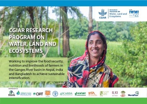
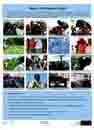
This interactive poster was presented at the 2013 Stockholm World Water Week. It describes the results of a 'public good game' carried out with farmers in the polder zones of coastal Bangladesh in order to understand determinants of contributions to maintain a public good.

Working Paper on Population Growth and Natural Resources Pressures in Pursat Catchment

Reports & Research
Décembre, 2013
Cambodge

This working paper examines population growth in Pursat and its potential impact on food demand and land and water resources in a systematic and integrated manner. The main purpose of the paper is to kick-start a policy debate on population dynamics and food and water security in Pursat. The paper provides background information, observations and empirical analysis of resource demand (real or perceived) associated with population growth and policy decisions related to food and water security.

Water-use accounts in CPWF basins: Simple water-use accounting of the Yellow River Basin

Reports & Research
Décembre, 2010
Chine
Asie

This paper applies the principles of water-use accounts, developed in the first of the

series, to the Yellow River basin in China. The Yellow River rises in the Bayan Har

Mountains in Qinghai Province in western China, and empties into the Bohai Sea. A

unique feature of the river is the large amount of silt it carries.

Net runoff is about 14% of total precipitation. Forest and woodland cover 9% of the

basin and use about 15% of the precipitation. Grassland covers much of the upper part

Water-use accounts in CPWF basins: Simple water-use accounting of the Karkheh Basin

Reports & Research
Décembre, 2010
Iran
Asie occidentale

This paper applies the principles of water-use accounts, to the Karkheh River basin in Iran.

The northern part of the Basin where the Karkheh and its tributaries rise is mountainous, cooler, and wetter. The River spills out on to the hotter, lower semi-arid plains at its southern end. Precipitation, mainly in winter, varies from 400-500 mm in the upper part of the Basin falling to about 230 mm in the lower reaches.

Wavelet-based spatio-temporal fusion of observed rainfall with NDVI in Sri Lanka

Conference Papers & Reports
Décembre, 2012
Sri Lanka
Asia du sud-est

Availability of rainfall time-series is limited in many parts of the World, and the continuity of such records is variable. This research endeavors to extend actual daily rainfall observations to ungauged areas, taking into account events of rainfall as well as cumulative total daily rainfall, over a period of 11 years. Results show that rainfall events histograms can be reconstructed, and that total cumulative rainfall is estimated with 85% accuracy, using a surrounding network of rain gauges at 30-50 Km of distance from the point of study.

Willingness to pay for improved rural water supply in Goro-Gutu District of eastern Ethiopia: An application of contingent valuation

Journal Articles & Books
Décembre, 2012
Éthiopie
Afrique
Afrique orientale

This study employs a contingent valuation method to estimate willingness to pay for improved rural water supply. It provides information on the demand for improved services and the potential for them to be sustainable. The analysis was based on data collected from 132 households using rural water utilities for at least three years. Both binary and ordered probit models were used to examine the determinants of willingness to pay. The estimated mean and median willingness to pay was found to be Birr 6.83 and 5.87 per household per month.

Water-use accounts in CPWF basins: Simple water-use accounting of the Mekong Basin

Reports & Research
Décembre, 2010
Viet Nam
Cambodge
Laos
Thaïlande
Asia du sud-est

This paper applies the principles of water-use accounts, developed in the first of the series, to the Mekong River basin in Southeast Asia. The Mekong Basin covers six

countries, the River rises in China, but there are substantial downstream tributaries

from Thailand, Laos, Cambodia, and Vietnam, and from a small area in Myanmar. A

unique feature is the reverse flow from the Mekong to the Tonle Sap via the Tonle Sap

River at the height of the wet season flow and its ebb as the river levels fall.