Introduction
The Deforestation and Forest Degradation in the Amazon Biome map was produced by Imazon in order to contribute towards monitoring in the region. The methodology applied simultaneously generates mapping of deforestation and forest degradation [caused by logging activity and forest burning] using Landsat satellite images. Existing methods individually detect and map those processes, which can lead to overlaps in the results and increasing uncertainty in estimates of annual deforestation rates. That happens because in the most intense Landsat images forest degradation can be confused with deforestation. Deforestation is a process for converting forest to other land uses, such as pastures, agricultural areas, mining, or even for urbanization. To do that it is necessary to completely remove the original forest cover, while forest degradation partially and temporarily removes that cover. For example, timber harvesting involves the removal of a certain number of trees (3 to 5) per hectare and opening of roads and logging decks for storing timber; forest fires open clearings through burning trees, while other trees receive lower impacts. Those processes lead to the reduction of the original forest carbon stocks and of biodiversity. The methodology presented in this study makes it possible to map deforestation and forest degradation simultaneously, reducing possible zones of “confusion” in mapping those two types of processes. Another important contribution is the capacity for mapping deforestation in up to one hectare. We used Landsat images acquired during the period of 2000 to 2010, which annually cover most of the Amazon Biome, in order to produce the first results of this new monitoring system at Imazon. The data [from satellite images] are normalized in space and time and quantitatively analyzed, which makes it possible to establish automatic, generic and consistent classification rules. We also applied computing rules to detect possible classification inconsistencies over time and correct those problems. Finally, the maps generated with automatic classification are inspected and edited by analysts in order to correct eventual errors. Those mapping results are later used to estimate the annual rate for deforestation and degradation through mathematical methods, for the referenced date of August 1 [used officially by the Brazilian government for that purpose]. The sections below present details of the methodology, the mapping results and the next steps in this Imazon monitoring project.
Methodology
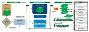
Landsat TM/ETM+ satellite images were acquired from several sources. Those data and their metadata were structured into an image server to facilitate access and digital processing. Processing of satellite images for generating maps occurs in five stages (Figure 1).
- Stage 1 – Pre-Processing. The first step in the methodology consisted of registering the Landsat images (Figure 2) in a reference base – Geocover (GLCF, 2000). Control points (20-30) between the Landsat images and the reference base were collected and an algorithm based on triangulation and resampling by the nearest neighbor was applied. That guaranteed a record between the images with a positioning error of less than 1 pixel. We applied radiometric calibration techniques, removal of smoke noise (Carlotto, 1999), and removal of the spectral atmospheric signal (Souza Jr. and Siqueira, 2013). In that manner data from the satellite images are converted from a digital number (DN) for surface reflectance.
- Stage 2 – Construction of a Spectral Library. Consists of identifying pure spectral components (endmembers) in order to estimate their abundance in each pixel. The endmembers of interest for forest monitoring are: green vegetation, non-photosynthetic vegetation (NPV), soil, cloud and shadow. The process for identifying and creating the spectral library involves identifying the spectral curves that have the potential to be endmembers. Next, a visual inspection of those curves is made for the final selection of the set of those pure components.
- Stage 3 – Spectral Mixture Modeling (MME). The reflectance images processed in Stage 1 are combined with the endmembers obtained in Stage 2 to estimate the abundance of those pure components in each pixel of the image. To do that, we applied the spectral mixture modeling technique (MEE), using the spectral library of those pure components. The fraction images resulting from the MME were used to calculate the NDFI (Normalized Differencing Fraction Image) (Souza Jr. et al., 2005a), and combined in a classifier through a generic decision tree in the next stage.
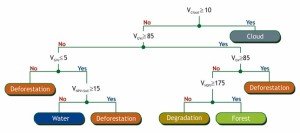
- Stage 4 – Automatic Classification. We built decision tree empirically in order to classify the deforested areas, degraded forests, water bodies, shade and cloud (Figure 3). As an entry for classification we used the fraction images obtained with the MME and the NDFI spectral index NDFI.
Figure 1. Methodology applied in processing Landsat images and implemented in the ImgTools software.
- Stage 5 – Post-Classification. Spatial and temporal filers were constructed in order to remove spurious classifications and non-allowed temporal transitions between mapping classes, respectively. The spatial power makes it possible for given classes to be defined together with their least mappable area. That way, isolated pixels classified in a given image can be eliminated and substituted by the dominant class in their neighborhood. The temporal filter is a set of rules for non-allowed transitions that are applied to each image classified in a given year. That way, it is possible to remove clouds and correct non-allowed transitions.
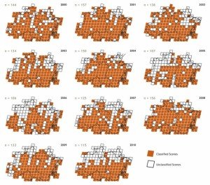
Figure 2. Landsat TM/ETM+ images used in mapping deforestation and forest degradation. A total of 1,465 images were acquired, predominantly (90%) from the image server of the National Institute for Space Research (Inpe). The acceptable percentage of cloud cover was up to 30%, but the great majority of images had a maximum of 20%. The area mapped annually ranged from 106 to 157 Landsat images of a total of 192, with wide coverage of areas under pressure by deforestation and forest degradation. For most of the State of Amapá it was not possible to obtain annual images in a systematic fashion and thus statistics on deforestation and forest degradation are not presented for that state.
In order to automate the methodology described above, we developed a software called Tools, utilizing the IDL programming language (Figure 1) (Souza Jr. and Siqueira, 2013). This software automatically processes a set of scenes, producing maps and statistics (see example in Figure 4).
Figure 3. Empirical decision tree used for classifying deforestation and forest degradation.
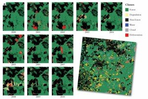
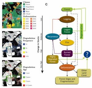 Figure 4. Example of monitoring dynamics of deforestation obtained with a temporal series of Landsat images using the methodology developed by Imazon (a). For base year (2000), we mapped all of the areas already deforested and without forest cover to generate a reference map of the forest areas (including those already degraded). Old secondary forests were estimated by applying the map of deforested areas identified by Prodes up to 2000. Increments in deforestation identified each year are utilized to update the remaining forest baseline, as is the case with areas of degraded forests not maintained as such until they are eventually deforested. In that way, it is possible to quantify the area affected by deforestation and deforestation and forest degradation between each pair of consecutive images. The annual maps are used to generate maps of age of deforestation (b) and forest degradation, and forest degradation frequency maps. In this way it is possible to map and quantify the complex dynamic of iterations of degradation of forest cover degradation (c) (Souza Jr., 2013).
Results
The results of mapping deforestation and forest degradation in that study are presented in Table 1 and in Figure 5. The statistics were annualized in order to estimate the annual rates of deforestation and forest degradation based on the method described in Box 1. For the period of 2000 to 2010 the Imazon system for monitoring deforestation and forest degradation estimated 169,074 square kilometers of deforested areas in the Amazon Biome (Table 1A). The area of forest affected by forest degradation was 50,815 square kilometers, in other words, a forest area altered by timber harvesting and/or burning equivalent to 30% of the area converted by deforestation (Table 1B). The highest peak of deforestation occurred 2004 (24,446 square kilometers), and the smallest deforested area was detected in 2010 (5,496 square kilometers) (Table 1A). With regard to forest degradation, the peak recorded was for 2008 with 8,396 square kilometers of degraded forests, in other words, 68% of the area deforested for that year, which reached 12,403 square kilometers. The lowest rate of forest degradation also occurred in 2010 with 3,731 square kilometers (68% of the deforestation in that year; Table 1).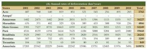

Table 1. Estimates of annual rates of deforestation (A) and forest degradation (B) obtained with Landsat images for the period of 2000 to 2010.
* It was not possible to estimate the annual rate due to the low number of observations with Landsat images during the period analyzed (only 27 out of 143 scenes with low cloud cover).
The historical series for deforestation presented a tendency of high rates of forest destruction for the period of 2001 to 2005 (average of 21,893 square kilometers per year) while forest degradation remained stable during this period with an average annual rate of 4,627 square kilometers per year. Beginning in 2006, we observed a notable tendency towards a drop in deforestation, albeit with fluctuations and a slight increase in the annual rate of forest degradation compared to the period of 2001 to 2005 (Table 1; Figure 5). The average deforestation rate from 2006 to 2010 was 11,922 square kilometers per year, and for forest degradation it was 5,536 square kilometers per year.
The States that most contributed towards the deforestation total for the period analyzed were Pará (35%) and Mato Grosso (31%), followed by Rondônia (16%) and Amazonas (10%) (Figure 5B). The State of Mato Grosso led in terms of forest degradation, contributing 48% of the total for that period. Pará was second in the forest degradation ranking with 32%, and Rondônia (7%) and Acre (5%) came next, with lower rankings (Figure 5C). The Prodes system detected a deforested area of 165,310 square kilometers in this area, in other words an area 2% smaller than the deforested area (169,074 square kilometers) detected by the Imazon system. The difference between the total deforestation detected by the two monitoring systems is very small, but it is greater between each year, with an absolute average of 2,270 square kilometers (Figure 5). Those differences may be explained through the following hypotheses: scale of monitoring, which is more detailed in the Imazon system; inclusion or not of forest degradation in monitoring; and by the different dates of the images, between the annualization methods (i.e., annual rate) of the measurements done by the satellite images. Nonetheless, the deforestation estimated with Prodes and with the Imazon system both presented a similar tendency of an increase in deforestation from 2001 to 2005, followed by a notable drop from 2006 to 2010.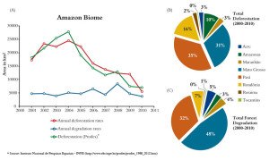
Figure 5. Annual rates of deforestation and forest degradation (A) in percent units contributions of the States of the Amazon Biome for these processes (B and C, respectively).
Box 1 – Calculating the Annual Rate
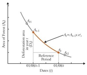
The annual rate is an estimate of the area of forest affected by deforestation or by forest degradation in a given year, generally expressed in absolute terms (square kilometers per year). Brazil uses the date of August 1 as the reference for estimating the annual deforestation rate. That means that the annual deforestation rate estimated for the period of August 1 to July 31, known as the reference period, which is also adopted in this study. The Landsat satellite images generally used for monitoring the Amazon are acquired on dates that do not coincide with the reference period used for estimating the annual rate. It is thus necessary to project the measurements made with satellite data for that period of reference by using mathematical methods. We adopted the method proposed by the Food Administration Organization (FAO) to estimate the annual deforestation rate in the Amazon (Table 1A). We first applied the method suggested by Puyravaund (2003) to calculate the annual percentage rate of forest cover lost. The formula assumes that the area of forest lost to deforestation decreases over time according to an exponential rate, given by: where At-1 and At-2 are the forest areas mapped in times t1 and t2, expressed in years, beginning with an initial year (t0= 2000). The result,r(t,t-1), represents the percentage rate of forest loss normalized for the period between t1 – t2(expressed in years). With the value of it is possible to calculate the annual deforestation rate (in km2/year) for a given reference period, with the following equation:
![]() where At-1 and At-2 are the forest areas mapped in times t1 and t2, expressed in years, beginning with an initial year (t0= 2000). The result,r(t,t-1), represents the percentage rate of forest loss normalized for the period between t1 – t2(expressed in years). With the value of it is possible to calculate the annual deforestation rate (in km2/year) for a given reference period, with the following equation: For example, for t = 01/08/2001 and t – 1 = 01/08/2000 the annual deforestation rate in equation (2) is obtained by:
where At-1 and At-2 are the forest areas mapped in times t1 and t2, expressed in years, beginning with an initial year (t0= 2000). The result,r(t,t-1), represents the percentage rate of forest loss normalized for the period between t1 – t2(expressed in years). With the value of it is possible to calculate the annual deforestation rate (in km2/year) for a given reference period, with the following equation: For example, for t = 01/08/2001 and t – 1 = 01/08/2000 the annual deforestation rate in equation (2) is obtained by:
where the rate r2000,2001 is calculated by Equation 1, using images obtained during 2000 and 2001. In the example above, A2000 is the initial forest area projected or observed in 01/08/2000. For the other years, Dt is the annual deforestation rate, normalized for the reference period between the years t – 1 and (2001,…,2010), and At-1 is given byA*t-2-Dt-1, for (2002,…,2010) (Figure 6).
Figure 6. Example of the process for annualizing the deforestation rate using the method described in this section.
To calculate the annual rates for the States, we applied a mask, per scene, in order to apply that method only in the portions of a given State covered by the scene. For the cases in which there are gaps of one or more years in the Landsat images, we used the same estimate of for all of the reference periods between the two images acquired. Finally, when deforestation is detected for previous years in areas not observed because of cloud cover, those areas are distributed equally throughout the period in which clouds occurred. For example, if the deforested area A [in km2] occurs in 2003 and that area was under clouds during 2002 and 2001, we assume that A/3 happened equally in those years.
The same methodology described above was applied for estimating the annual rate of forest degradation (Table 1B), discounting the annualized deforestation for each period of reference to obtain the area of remaining forest in the respective year.
Conclusions
- he results of the Imazon monitoring system based on Landsat images and presented in this study show a tendency towards deforestation and total area deforested that are similar to those obtained with Prodes, the federal government’s system for monitoring the Amazon for the period of 2000 to 2010. There was a trend of increasing deforestation from 2000 to 2005, with average values of around 22,000 square kilometers per year, followed by a sharp drop in deforestation from 2006 to 2010, with an average of almost 12,000 square kilometers per year.
- Forest degradation affected an area equivalent to 30% of the total area deforested during the period analyzed, with an average of 5,536 square kilometers per year. Forest degradation leads to impoverishment of the forest in terms of biodiversity and carbon stocks, and it is thus important that it be monitored annually.
- The method for annualizing measurements using satellite images in order to calculate annual rates of deforestation and forest degradation is an important procedure that needs to be applied at municipal scales, in order to evaluate performance in controlling deforestation.
- Policies for controlling deforestation at the municipal scale should also include the area annually affected by forest degradation as an indicator for inclusion in the critical list for embargo by the Environmental Ministry.
- The next steps in this Imazon monitoring program include: quantification of the possible transitions between classes of forest, forest degradation and deforestation; modeling of carbon emissions associated with deforestation and forest degradation, including transition classes and the age and recurrence of forest degradation; characterization of those processes in protected areas; and an analysis of the impact of forest degradation on official deforestation rates.
- With the possibility of new data from the recently launched Landsat 8 (LDCM – Landsat Data Continuity Mission), Imazon intends to continue this monitoring during the future.
- It is also recommendable that that historical series on deforestation and forest degradation be constructed for periods prior to 2000, in order to provide a greater understanding of the relation between those processes and a more precise estimate of historic carbon emissions.
- Finally, we recommend the use of radar images for monitoring areas under frequent cloud cover, as is the case with the State of Amapá and other areas not mapped in this project.
Technical Data
Map prepared at the Imazon Geotechnology Sector (CGI) by Carlos Souza Jr., João Siqueira, Júlia Ribeiro and Márcio Sales. In Belém, Pará, Brazil. 2013. Graphic design: Luciano Silva (www.rl2design.com.br)
Bibliography
- Carlotto, M. J. 1999. Reducing the effects of space varying, wavelength dependent scattering in multispectral imagery. International Journal of Remote Sensing. 20(17). 3333-3344p.
- FAO. 2000. On Definitions of forest and forest change. Forest Resources Assessment. Working Paper 33. Rome. 13p.
- Puyravaud, JP. 2003. Standardizing the calculation of the annual rate of deforestation. Forest Ecology and Management. 177. 593-596p.
- Souza Jr., C. 2013. Monitoring of Forest Degradation: a review of methods in the Amazon basin. In: Global Forest Monitoring form Earth Observation, Ed. Achard, F. and Hansen, M. C., CRC Press – Taylor & Francis, 171-194p.
- Souza Jr., C. and Siqueira, J. V. 2013. ImgTools: a software for optical remotely sensed data analysis. In: XVI Simpósio Brasileiro de Sensoriamento Remoto (SBSR). Foz do Iguaçu-PR. 8p.
- Souza Jr., C., Roberts, D. A. and Cochrane, M. A. 2005a. Combining spectral and spatial information to map canopy damage from selective logging and forest fires. Remote Sensing of Environment. 98 329-343p. Doi: 10.1016/j.rse.2005.07.013.
- Souza Jr., C., Roberts, D. and Monteiro, A. L. 2005b. Multitemporal analysis of degraded forests in the Southern Brazilian Amazon. Earth Interactions. 9 (19) 1-25p. Doi: http://dx.doi.org/10.1175/EI132.1.
- The Global Land Cover Facility (GLCF), 2000. Landsat GeoCover Degree, 1.0. University of Maryland Institute for Advanced Computer Studies, College Park, Maryland. 10/23/2001.
Cartographic Sources
STATE BOUNDARIES: Instituto Brasileiro de Geografia and Estatística (IBGE), 2010; BOUNDARIES OF THE AMAZON BIOME: World Wildlife Fund (WWF), 2000; STATE AND NATIONAL CAPITAL: Instituto Brasileiro de Geografia and Estatística (IBGE), 2010; HYDROELECTRIC AND DAM PLATFORM: Programa de Aceleração do Crescimento (PAC), 2011; WORKS IN THE GROWTH ACCELERATION PROGRAM: Programa de Aceleração do Crescimento (PAC), 2011; OFFICIAL ROADS: Instituto Brasileiro de Geografia e Estatística (IBGE), 2006. Departamento Nacional de Infraestrutura de Transportes (DNIT), 2011. LAND REFORM SETTLEMENTS: Instituto Nacional de Colonização and Reforma Agrária (INCRA),
2012. MANAGEMENT PLANS: Instituto do Homem and Meio Ambiente da Amazônia, 2011; INDIGENOUS LANDS AND CONSERVATION UNITS: Instituto Sócio Ambiental (ISA), 2005; DEFORESTATION AND LAND COVER: Instituto do Homem and Meio Ambiente da Amazônia (Imazon), 2011.
Acknowledgments
We would like to thank the Fundo Vale for support in developing the methodology for monitoring with Landsat images, image process activities and publication of this map. The ImgTools software had developmental support from the Moore Foundation, Climate Land Use Alliance and Fundo Vale. The Gordon & Betty Moore Foundation supported the satellite image processing team in monitoring forest degradation and deforestation in protected areas of the Amazon. That project also received support from NASA through the Biological Diversity Program led by Dr. Mark Cochrane of South Dakota State University (Contract: NNX07AF16G) for operation activities in pre-processing and classifying images. Doctors Izaya Numata and Christopher Barber, of the University of South Dakota, supplied valuable suggestions and revisions of the processed images. We would like to thank them for those contributions.
Technical Team
The project received technical cooperation from: André Monteiro, Antônio Fonseca, Dalton Cardoso, Denis Conrado da Cruz, Luis Oliveira Jr., Marcelo Justino, Roberto Wagner Batista, Sâmia Nunes and Sanae Hayashi. We would also like to thank Cíntia Balieiro, who was a member of the processing team during the initial phase of this project.


